DUNE Project
Ocean Bottom Seismometer Data (FCT)
The two new broadband Ocean Bottom Seismometer (OBS) developed and built in Portugal at seismology Laboratories of Instituto Dom Luiz (IDL)/CEIIA within Project DUNE (PTDC/EAM-OCE/28389/2017), DUNE OBS (Fig. 1), were deployed between 25 May 2021 and recovered on the 15 October 2021 in SW Iberia on board RV Mário Ruivo from IPMA. The OBS01 with a GURALP Aquarius (120s-100Hz) and hydrophone HTI-04-PCA (100s-8KHz) was deployed at the surface position of 36.94966° N and 9.70266° W near the São Vicente Canyon (SVC at Figure 2), at a depth of 1993 meters. The OBS02 with a Silicon Audio (203-60) and hydrophone HTI-04-PCA was deployed at 37.498783° N and 9.499783° W at depth of 1300 meters, east of the Pereira de Sousa fault (PSF, see Figure 2). The main objective was to study the behaviour from the two ocean stations deployed in extreme noise area associate with ship traffic, sediments and tide currents. Normally we should avoid to deploy OBS in those areas.
The purpose of the DUNE OBS was the mitigation of the influence of the deep-sea currents on the instrument. The accessories (flag, radio antenna and head-buoy) are all inside the outer orange shell during the free-fall and recording period. After releasing the instrument from the anchor at the seafloor, the flag, radio antenna, flash beacon and head buoy are released from the frame and stand outside the outer shell to simplify its recover at the surface. The OBS01 GURALP Aquarius (120s-100Hz) seismometer is firmly connected to the OBS inner structure. This sensor is a triaxial orthogonal broadband seismometer operational at +/-90° with self-noise of -173 dB re(m/s2)2/Hz at 10s. The silicon Audio is a 3-axis force balance with interferometric transducer with a tilt tolerance of ±15°, with a dynamic range of 173dB and automatic mass center.
In this data quality check, we use two land stations, LX MESJ and LX MORF, belonging to the IDL seismology lab to compare local and distant seismic events (see Figure 2).
The land station LX MESJ is located in Messejana, near Aljustrel, at position 37.8395°N and 8.21983°W at an altitude of 250m above sea level (see Figure 2). The land station, LX MORF, is located in Marmelete, near Monchique, at position 37.30633°N and 8.5860°W at 650 meters above sea level. Both stations have the sensor installed in bedrock. The OBS are installed in sediments and normally noisier than bedrock.
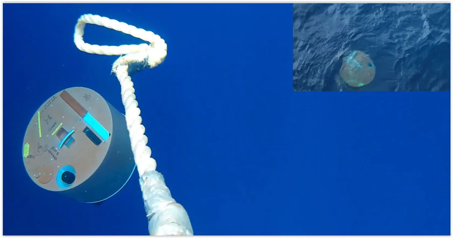
Figure 1 | DUNE OBS. New broadband OBS developed and build in Portugal with the new seismic sensor from GURALP Aquarius (120s-100Hz), silicon audio and a broadband hydrophone HTI-04-PCA. On the left DUNE OBS on free-fall in the water column. On the right: Recovery of the DUNE OBS with the flag, radio and flashlight outside the orange shell. The deployment and recovery on board Portuguese vessel, RV Mário Ruivo (IPMA).

Figure 2 |OBS campaign – Deployment of 2 DUNE-OBS, OBS01 and OBS02. Main geographical features shown: TAP – Tagus Abyssal Plain; HB – D. Henrique Basin; GB – Gorringe Bank; MPP – Marquês de Pombal Plateau; SVC – São Vicente Canyon; SP – Sagres Plateau; HAP – Horseshoe Abyssal Plain; HV – Horseshoe Valley; PSF – Pereira de Sousa Fault. MORF and MESJ are two land seismic stations operated by IDL. Three local events were selected to show data from local earthquakes, EV030621 in Monchique, EV170621 W of Sines and EV050921 near Aljezur. Figure made in GMT (Wessel et al., 2013)
The first local seismic event selected was an event that took place East of Monchique at 22:04 of 03/06/2021 with epicenter at 37.32°N 8.52°W (see Fig. 2). This event had magnitude ML 2.3 and 7 km depth. The day-plot of OBS01 and OBS02, are seen in Fig. 3, and it was made with ObsPy (Krischer et al., 2015). The normalize daily spectrogram of OBS01 in Fig. 4 made with GMT (Wessel et al., 2013) and the seismic event plot, Fig.5, in SEISAN software (Havskov et al., 1999; Havskov et al., 2020).

Figure 3 | Day-plot – Records of OBS01 and OBS02 of local seismic event occur at 22:04 03/06/2021 East of Monchique with magnitude ML 2.3.

Figure 4 | Normalized daily spectrogram – The spectrogram of 03/06/2021, from 1-40Hz, showing the local seismic events at 22:04. During this day was observed several ship traffic events, fish bumps at 14h and others local seismic events.
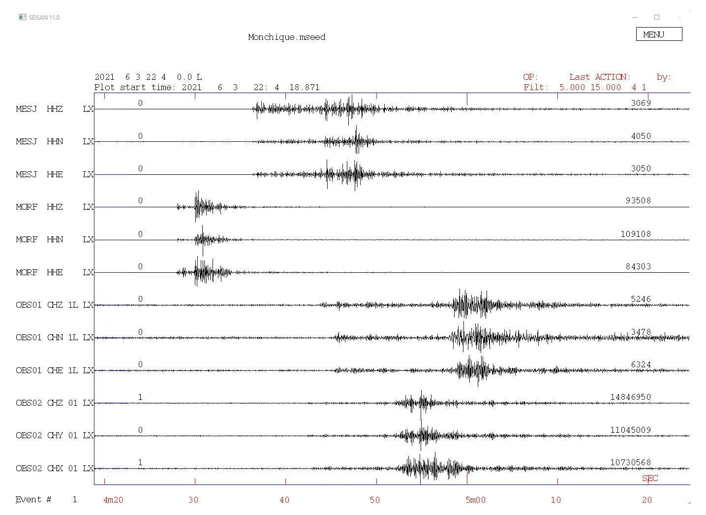
Figure 5 | Seisan – Local seismic event recorded in land stations MESJ and MORF and in the OBS01 and OBS02.
The second local seismic event selected was an event that took place West of Sines at 06:12 of 17/06/2021 with epicenter at 37.78°N 9.57°W (see Fig. 2). This event had magnitude ML 2.2 and 12 km depth. The day-plot of OBS01 and OBS02, are seen in Fig. 6, the normalize daily spectrogram of OBS01 in Fig.7 and the seismic event plot in Fig.8.
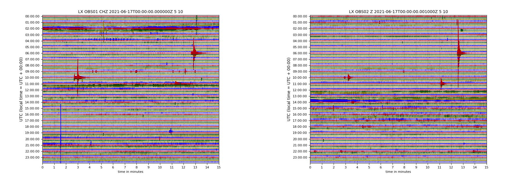
Figure 6 | Day-plot – Records of OBS01 and OBS02 of local seismic event occur at 06:12 17/06/2021 West of Sines with magnitude ML 2.2
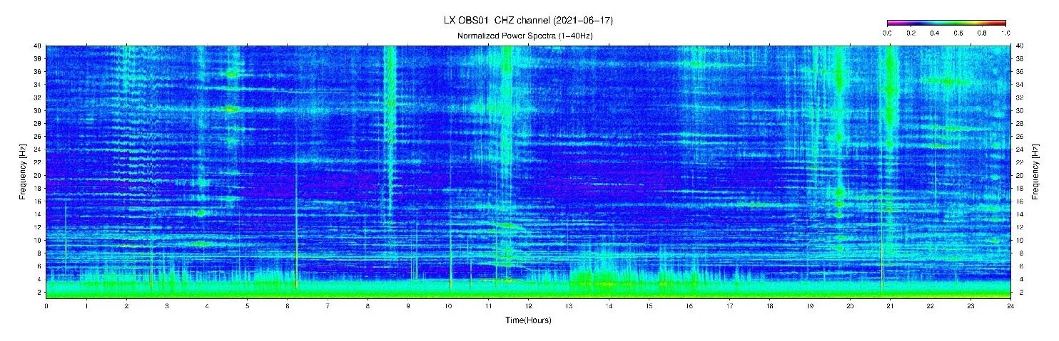
Figure 7 | Normalized daily spectrogram – The spectrogram of 17/06/2021, from 1-40Hz, showing the local seismic event at 06:12. During this day was observed several ship traffic events and others local seismic events.
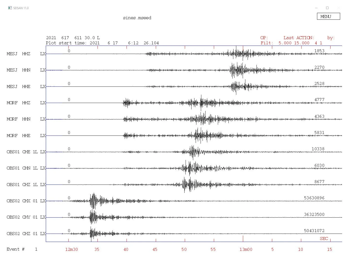
Figure 8 | Seisan – W of Sines event recorded in land stations MESJ and MORF and in the OBS01 and OBS02.
The third local seismic event selected was an event NW Aljezur at 08:59 of 05/09/2021 with epicenter at 37.44°N 8.87°W (see Fig. 2). This event had magnitude ML 2.6 and 21 km depth. The day-plot of OBS01 and OBS02, are seen in Fig. 9, the normalize daily spectrogram of OBS01 in Fig.10 and the seismic event plot in Fig.11.
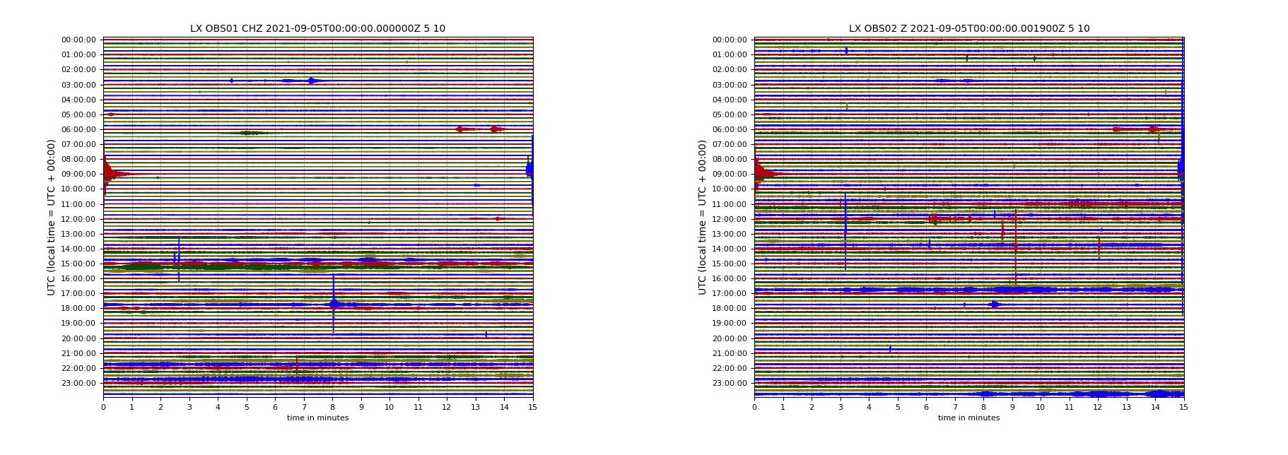
Figure 9 | Day-plot – Records of OBS01 and OBS02 of local seismic event occur at 08:59 05/09/2021 NW of Aljezur with magnitude ML 2.6
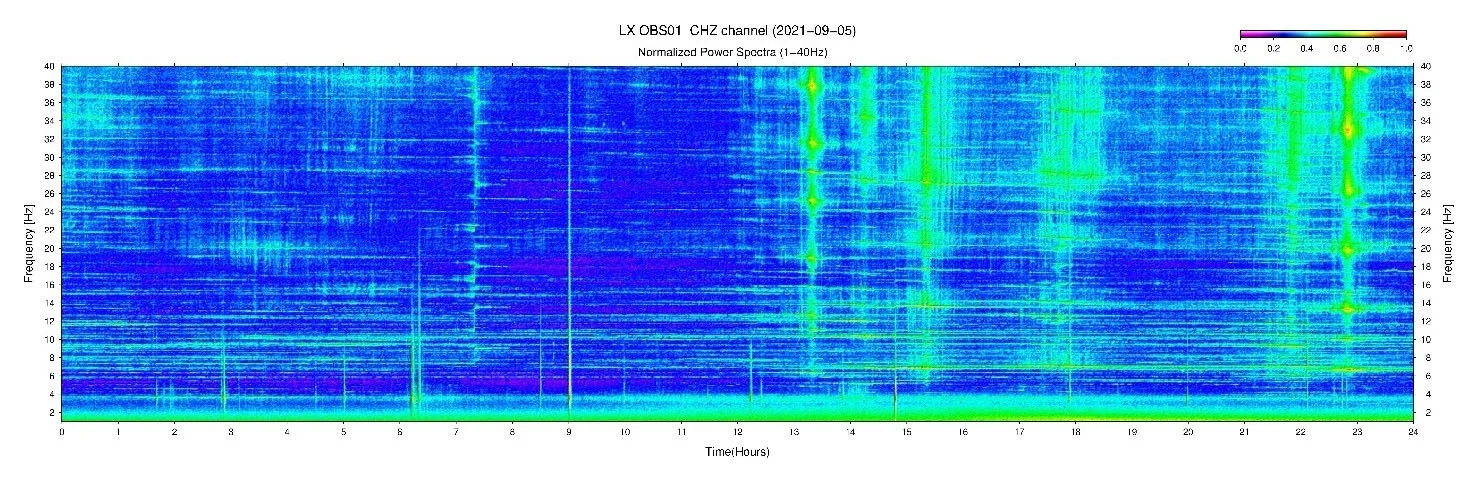
Figure 10 | Normalized daily spectrogram – The spectrogram of 05/09/2021, from 1-40Hz, showing the local seismic event at 08:59. During this day was observed several ship traffic events and others local seismic events.
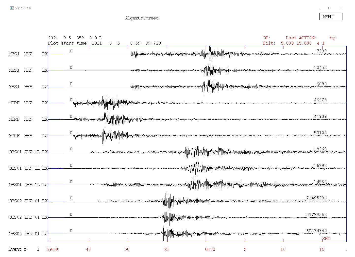
Figure 11 | Seisan – NW of Aljezur event recorded in land stations MESJ and MORF and in the OBS01 and OBS02.
The fourth seismic event selected was a distant event from Alaska Peninsula at 06:15 (origin time) of 29/07/2021 with epicenter at 55.54°N 158.01°W. This event had magnitude Mw 8.2 and 43 km depth. The day-plot of OBS01 and OBS02, are seen in Fig. 9, the normalize daily spectrogram of OBS01 in Fig.10 and the seismic event plot in Fig.11.
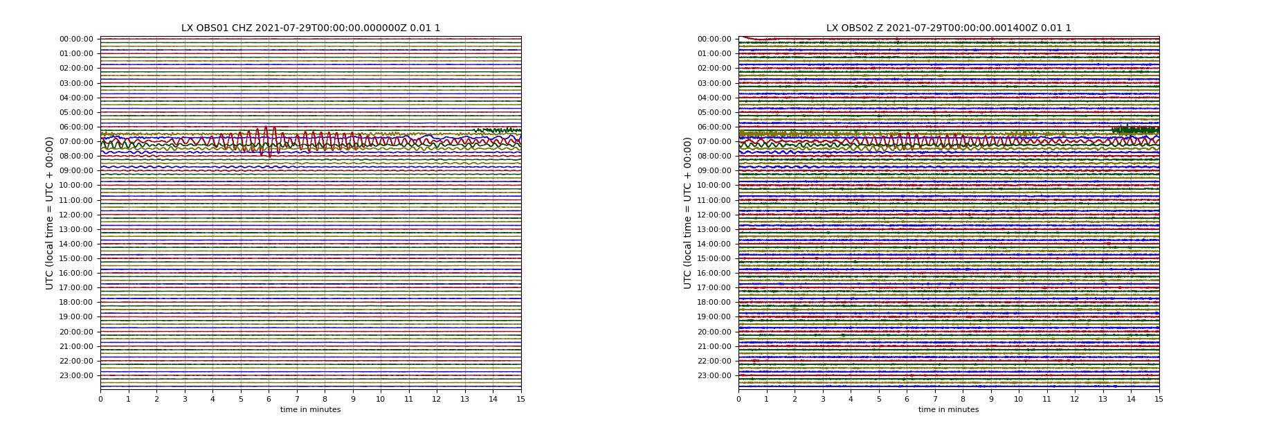
Figure 12 | Day-plot – Records of OBS01 and OBS02 of distant seismic event occur at 06:15 29/07/2021 in Alaska Peninsula with magnitude Mw 8.2.
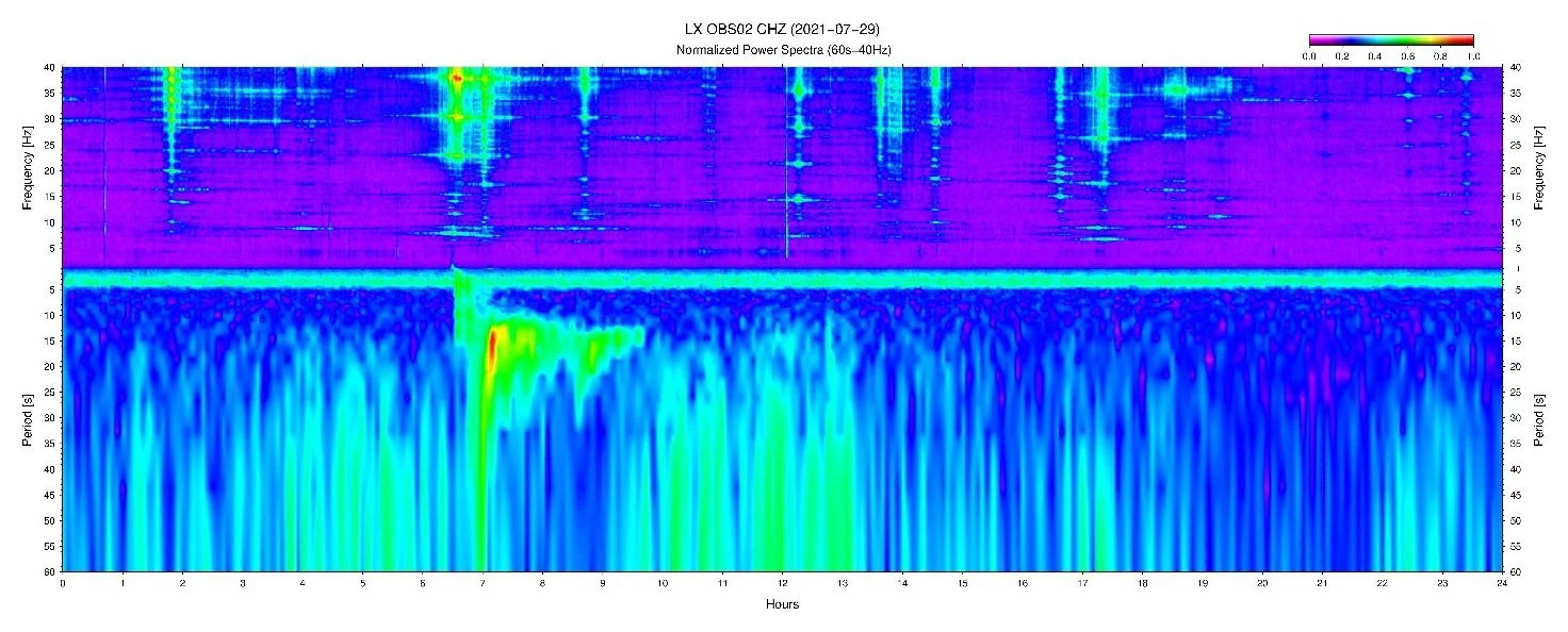
Figure 13 | Normalized daily spectrogram – The spectrogram of 29/07/2021, from 60s-40Hz, showing the distant seismic event at 06:12 (origin time). During this day was observed several ship traffic events and others local seismic events.
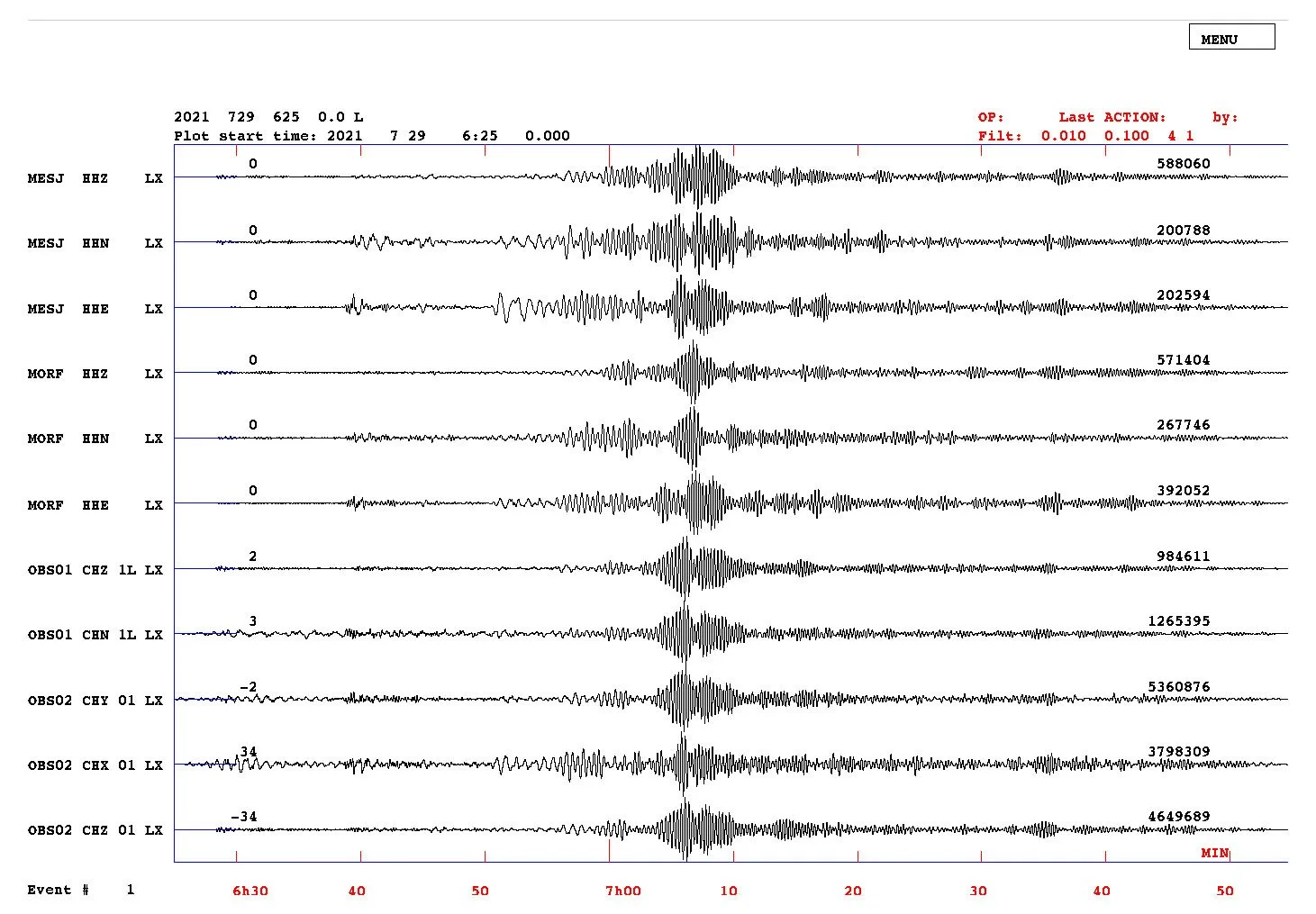
Figure 14 | Seisan – Alaska Peninsula event recorded in land stations MESJ and MORF and in the OBS01 and OBS02.
The main objective for OBS is recording seismic events, however, as expected, the data of land stations installed in bedrock are better than the data from OBS installed in sediments. Nevertheless, the main seismic phases events were recorded in OBS data.
Another quality factor could be the marine mammals monitoring using passive acoustic instruments. Provided that the species of interest makes a sound that can be used as a cue to indicate that an individual is present, then passive monitoring can overcome some of the limitations of visual surveys. These instruments enabling long term datasets to be collected throughout all seasons and have been used to address a variety of research issues, ranging from fine scales studies of animal behavior to migration patterns. During the DUNE deployment we find as well whales vocalizations as illustrated in the Fig.15
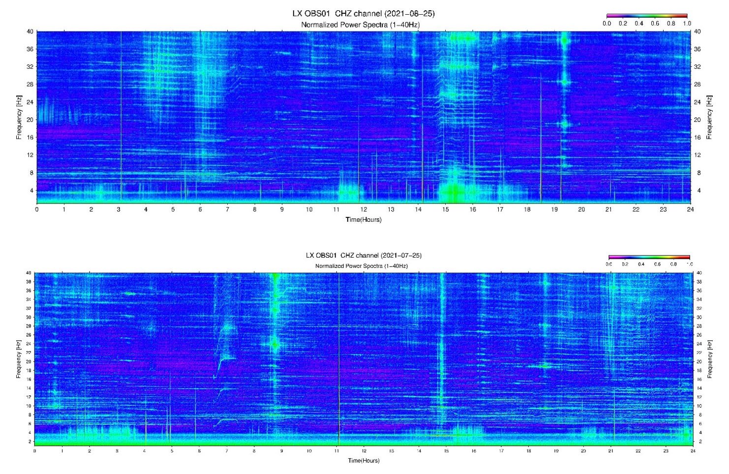
Figure 15 | Whales vocalization – Fin whales call between 20-24Hz at the above spectrogram (25/06/2021 – between 0 and 2 hours) and humpback whale (25/07/2021) around 7 hours on the bottom.
OBS measure ground motions, much like seismic stations on land do. However, deployment conditions in the seafloor are different from those in the continent as the seismometer can be protected from environment disturbances (e.g., wind, temperature) through installations several meters underground whereas OBS stay on the seafloor exposed to all oceanic physical phenomena. This makes an OBS more than a seismic station, recording in addition to all types of seismic data (of geological, biological or anthropogenic origin), also oceanographic information (currents) as noise data. The noise of oceanic origin significantly impairs the investigation of all other phenomena leading to major challenges and technical difficulties.
One of the challenges of seismic observations in the oceans regards the efficiency of noise reduction generated by oceanic processes. Understanding the sources and amplitudes of seismic noise in the oceans is important for improving OBS design in terms of instrumental capabilities and self-noise mitigation.
For OBSs, with large and heavy seismic sensor package, required in order to withstand the hydrostatic pressure at the seafloor, in combination with the very soft, water-saturated sediments, can result in a resonance system within the seismic interested frequency band. The DUNE-OBS suffer from this problem as seen in spectrograms of Fig.16.
This new design, however, is still highly exposed to the current flow. Later iterations are aimed, in the long-period noise band, since the tilt noise still needs to be mitigated. Research into solving this problem is already in progress and further work needs to be carried out to establish improvements in OBS design. Future work should focus in changing the seismic sensor position and disconnection from the OBS structure in a smaller package. This action should shift the natural frequency of the OBS-sediments coupling to outside seismological interested frequency band and should mitigate the tilt noise.
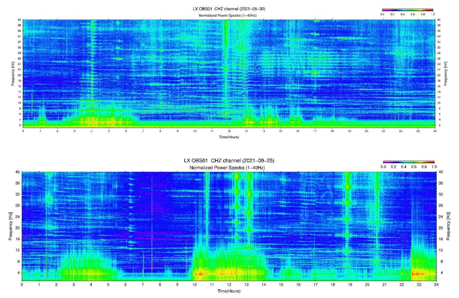
Figure 16 | Resonance OBS-sediments coupling – In the spectrograms from 30/05/2021 and 25/09/2021 is possible to see the resonance of OBS-sediments coupling.
References
Havskov and Ottemoller: SeisAn Earthquake analysis software, Seis. Res. Lett., 70, doi: 10.1785/GSSRL.70.5.532, 1999.
Havskov, J., Voss, P.H. and Ottemoller, L.: Seismological Observatory Software: 30 Yr of SEISAN. Seismological Research Letters, 91 (3): 1846-1852. doi: 10.1785/0220190313, 2020.
Krischer, L., Megies, T., Barsch, R., Beyreuther, M., Lecocq, T., Caudron, C., and Wassermann, J.: ObsPy: a bridge for seismology into the scientific Python ecosystem, Computational Science & Discovery, 8 (1), 014003, doi:10.1088/1749-4699/8/1/014003, 2015
Wessel, P., Smith, W. H. F., Scharroo, R., Luis, J. F., and Wobbe, F.: Generic Mapping Tools: Improved version released, Eos Trans. AGU 94, 409–410, doi: 10.1002/2013EO450001, 2013.